|
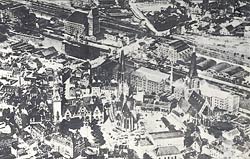 This
is a bombing map of Dresden. It is surrounded by aerial
photographs showing the types of building in the different
zones of the city. The aerial photographs make this
map so interesting as they show clearly what the different
parts of the city looked like. This
is a bombing map of Dresden. It is surrounded by aerial
photographs showing the types of building in the different
zones of the city. The aerial photographs make this
map so interesting as they show clearly what the different
parts of the city looked like.
The map is
closely linked with the other map of Dresden in this
section, and they make most sense if looked at together.
The pictures
of the houses and churches etc remind us that below
the colours and the shading were people, all trying
to live their lives as best as they were able.


|