|
Map:
RAF
Dresden Map, 1943
| |
|
|
| "Tenement
buildings in the Inner Residential Zone may be burnt out
under heavy I.B. attack. The effect of H.E. is not hard
to imagine." |
| |
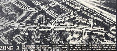 |
| "The
suburbia of Germany. These rows of small houses with their
own gardens make a poor target for either I.B. or H.E.
attack. They represent the more recent building on the
outskirts of cities but there is not as much of this area
as there is in England." |
| |
Read the comment
under the photo Figure 3, which shows the houses in Zone 2a
on the map. You need to know that I.B. stands for incendiary
bomb (fire bomb) and H.E. for heavy explosive bomb.
Do you think that
the comment about the effect of these bombs is intended to
get the bombers to avoid these areas because of what would
happen, or to try to hit them ?
You might also
like to read the comment under Figure 6 on Zone 3 to inform
your thinking.
|