|
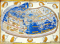 Although
it is known as 'Ptolemy's World Map', rather strangely
this map was printed more than 1000 years after Ptolemy's
death! Although
it is known as 'Ptolemy's World Map', rather strangely
this map was printed more than 1000 years after Ptolemy's
death!
All
the maps produced by this ancient Greek cartographer
were lost until a copy of his book was translated from
the original Greek in 1407.
Ptolemy's
maps were based on measurements and calculations linked
to astronomical observations. The rediscovery of his
work in the 15th century was to have a far-reaching
influence on how future maps were constructed.
In
the Middle Ages the most important things on maps were
usually shown as being the largest and the actual size
of the country, town or castle was considered of less
significance. Modern maps reflect the lasting legacy
of Ptolemy as the use of scale based on accurate mathematical
measurement is central to them.

|