|
Map:
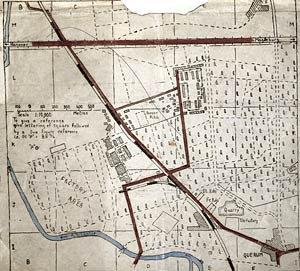
Prisoner
of War Map, 1944
How
far is it?
You will see that
the map includes a detailed scale to help the prisoners to
work out distances accurately.
Click on the
picture above to see an enlarged copy of the map (91kb).
You may want to print the map and measure the scale with a
ruler to answer the question below.
Using the map's
scale, how far do you estimate it was for a prisoner who managed
to escape at the quarry and creep through the woods to the
road to Magdeburg?
Click on the
questions to reveal the answers.
|