|
 Although
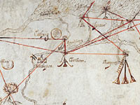
this map looks rather roughly drawn, it was a very important
one in its day. Elizabeth I was Queen of England and
the country was at war with Spain. The
biggest fear of the time was that Spain would try to
invade England, as in fact did happen in 1588 (you will
probably have heard about The Spanish Armada). Although
this map looks rather roughly drawn, it was a very important
one in its day. Elizabeth I was Queen of England and
the country was at war with Spain. The
biggest fear of the time was that Spain would try to
invade England, as in fact did happen in 1588 (you will
probably have heard about The Spanish Armada).
In a world
without electronic communication, the challenge was
to find as quick a means as possible to report any sighting
of an invasion fleet to London. A chain of beacons (fires)
on high points (such as hills and church towers) was
built. If the enemy was spotted, the beacon closest
to them would be lit. This could be seen by the keeper
of the next beacon, whose own beacon would then be lit.
This pattern would be repeated again and again all the
way to London.
During Tudor
times this was the quickest and most effective way of
sending such vital information. The red lines on the
map show the direction that each beacon keeper would
look towards as he waited for a signal.


|