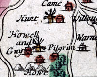
It
is not always a good idea to believe everything you
see on a map. There are cases of features, names and
even places being invented by mapmakers. However, by
choosing not to include something that is there,
a false impression is also created in the viewer's mind.
This
map is an example of 'what was left out'. Richard Forde
was commissioned to make this map of Barbados, an 'exact
survey', for King Charles II showing all the relevant
information. Windmills, population details, important
economic features and more are all included on the map
or in the notes in the panel.
However,
Forde was a Quaker and as such he disagreed with the
Church of England. He was also a pacifist. These beliefs
influenced the map he drew because he didn't show any
of the churches or any of the fortifications!

|