Antarctica,
or the Southern Continent, remains one of the most inhospitable
places on Earth, and accurate mapping has not been possible
until recently.
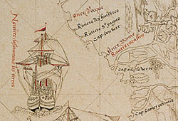
This
late 16th century map is a work of fiction. The exact
mapmaker is not known, but the map was produced in Northern
France and was probably accepted as genuine at the time.
It is not difficult to see how this could happen, for
the shape of the coastline is authentic looking and
the place names appear realistic.
It
is not known if any sailors actually attempted to use
this map of a voyage in these waters, but if they had
the consequences would probably have been disastrous.

|