|
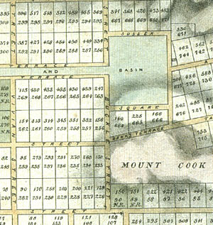 Most
plans and maps record what actually exists, but sometimes
they outline what is desired. This is plan of the city
that was to become the capital of New Zealand. The New
Zealand Company produced it in 1840. Most
plans and maps record what actually exists, but sometimes
they outline what is desired. This is plan of the city
that was to become the capital of New Zealand. The New
Zealand Company produced it in 1840.
The
plan was intended to attract settlers to the city. All
the features of the city are presented very neatly,
as it was believed that organisation and order were
the two main things that would attract settlers to this
part of the islands.
The
map shows a grid-like system of roads, this was probably
not the most appropriate layout as the actual place
where the city was located was hilly with a rugged coastline.

|