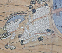
TThis
is one of the earliest surviving maps of Kashmir. It
was probably made by Abdur Rahim who lived in Bukhara
(today in Uzbekistan) around 1836. It follows the Islamic
map making tradition of having south at the top. This
very detailed map of an important part of the world
was acquired by Captain Wade, an English soldier serving
in the area.
The
colour coding shows what the land was used for: light
green indicates cultivated fields, dark green shows
village groves and brown is for bare earth. The city
of Srinagar is clearly shown as important and its famous
Shalimar Gardens can also be seen. The language of the
map is Persian. It is easy to see why Captain Wade noted
the 'extreme minuteness of its information' when he
showed the map to Government officials. Its importance
was immediately realised and copies were ordered to
be made.

|