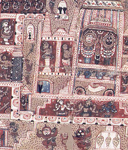
This
is a souvenir map from India, it is called a patas.
Many patas were produced in the 19th century
as souvenirs for Hindu pilgrims (travellers) visiting
sacred sites. This map is from the town Puri, in Orissa,
which is in eastern India.
The
centre of the map shows the Great Temple with the walls
around it. The god Jagannatha, his brother and sister
are inside the temple. Outside the city walls the map
is decorated with images of the god Vishnu, other local
gods and scenes from the story of Rama and Sita.

|