|
 We
take detailed and accurate maps of all parts of the
world for granted today and it can be difficult to appreciate
just how important and valuable they once were. The
17th century was a time when the sea faring nations
of Europe were competing for control over the continent
of South America. We
take detailed and accurate maps of all parts of the
world for granted today and it can be difficult to appreciate
just how important and valuable they once were. The
17th century was a time when the sea faring nations
of Europe were competing for control over the continent
of South America.
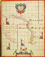
This map
and chart were in an atlas that was captured by English
pirates from a Spanish ship in 1680. Besides the coast-line
maps there were charts for individual ports that enabled
the sailing ships to avoid the shallows and rocks as
they made their way in. There are 165 maps and charts
in this volume altogether. It is believed this was the
only detailed map of this coastline that existed
at the time and it was therefore of tremendous value.


|