|
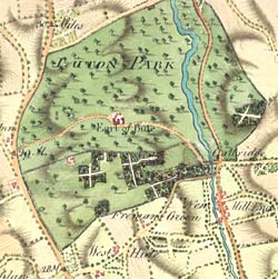
 This
map is taken from an atlas that the Earl of Bute had
made for himself. Bute was a very important man, he
had been King George III's tutor and later became Prime
Minister. This
map is taken from an atlas that the Earl of Bute had
made for himself. Bute was a very important man, he
had been King George III's tutor and later became Prime
Minister.
Each of the
maps shows a different route from London to Bute's stately
home at Luton Hoo. As in politics today, friends and
allies were very important but in the 18th century you
could not ring, text or email them with your plans!
You had to call in and discuss things in person.
Bute's collection
of maps showed the country houses where other influential
figures lived so that he could plot his route home according
to who he wanted to talk with on the way.
.


|